Queried Menhirs in St Buryan
Queried Menhirs
Queried Menhirs in St Buryan
On this page...
ST.BURYAN 12
BOLEIGH
prostrate stone at 4383/2478, in croft, not marked on OS.
 Russell listed* this 3.86 metre (12’9”) long stone in 1959 as lying prostrate by a hedge “possibly on recent turf”, and considered it a queried fallen menhir. The stone was much weathered, slightly rounded at one end and square at the other.
The OS visited the site in 1960 and recorded* that Russell had referred to a large recumbent stone lying against the west side of a hedge at the above grid reference; the stone was rectangular in section but “there are no indications that the stone was ever erect but its regular size and shape suggests a possible menhir”.
Barnatt listed this stone as being a probable fallen menhir.* What happened to it subsequently is not known but ST.BURYAN 19 was erected in 1988 in a field opposite the recorded location of this stone.* Is it the same one?
I visited the site in April 1988 and found a large stone lying in the corner of an overgrown enclosure immediately to the north of Borah Chapel. The stone was mostly covered by gorse bushes and difficult to see properly although the northern end did look pointed and the stone had an overall smooth appearance. In 1989 it was noted* that Russell’s stone had been rediscovered in the corner of a large field well hidden by bracken and completely overgrown by ivy at c.4382/2475.
However, when I visited the area again in October 1996 I failed to find this stone but did notice a long smooth stone about 3.72 metres (12’) in length, lying flat and half buried in the turf, with its widest end partially covered. It lies about 6.2 metres (20’) south of a gap/gate in the field hedge west of the above grid reference, at c.4375/2479, in an area littered with partially exposed boulders showing above the grass. It looks remarkably like a shaped menhir but does not lie on turf as did the stone listed by Russell.
ST.BURYAN 13
BOLEIGH
stone at 4343/2452, in a field hedge, not marked on OS.
 A large flattish stone stands incorporated into the northeast side of a hedge in the field immediately east of the Merry Maidens Circle at a point where the hedge has a distinct curve.
It is 1.75 metres (6’) tall and 1.24 metres (4’) wide, with both the Pipers and Gûn Rith in clear view (as well as the Maidens before intervening hedges were built). It was discovered by Barnatt* when following an alignment from Gûn Rith to the circle.
Above: St.Buryan 13 (4/2007) Below: The Merry Maidens with Gûn Rith beyond (4/2007)
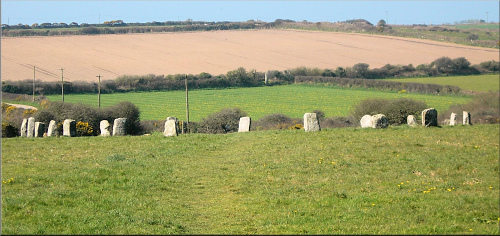 The stone also aligns with the position marking the approach of May Day sunrise.*
It was not mentioned by Russell.
ST.BURYAN 14
BOSKENNA
stone stump at 4260/2371, in a cultivated field, not marked on OS.
The stump of a possible third menhir is situated a few hundred metres to the west of the standing stone at Boscawen Ros [ST.BURYAN 3] in the next field. It is only 1.16 metres (3’10”) high and John Michell was informed* by the farmer that it was modern “so further comment would be tactless”. The fields here are named as Higher Gear and Lower Gear in the TA(1838) Nos.1444 and 1447, referring to a former enclosure or castle,* and it seems likely that, if ancient, this stone was once part of an Iron Age round.
ST.BURYAN 15
CHYANGWENS
stone at 4186/2709
stands in a hedge between Great Field and The Meadow TA(1838) Nos.1772 and 1781, not marked on OS.


A 1.65 metre (5’6”) wide thin stone, located on high ground, was first noticed by Michell* as a possible menhir since it was visible for miles around and within sight of other standing stones – the Pipers, the Blind Fiddler, Redhouse, Tresvennack, and the pair of stones at Drift. It is on the skyline when viewed from Boscawen-un Circle and also from the public footpath between Boscawen-ûn Farm and St Buryan. Michell considered this stone to be unique amongst the jumble of rocks and boulders making up the hedge in which it stands.*
ST.BURYAN 16
CHYANGWENS
prostrate stone at 4182/2707, in hedge, not marked on OS.


Possible menhir lying uprooted in hedge – on the right-hand picture, St.Buryan 15 is on the skyline, top left.
A fallen and half-buried stone was found by Michell close to the one standing in the hedge (St Buryan 15 - see above).* John Michell considered that this stone was on a five or six point alignment from Boscawen-ûn Circle marking Samhain/Imbolc sunrise and examination showed it was not a natural outcrop attached to the bedrock – an inspection during 1980 by Professor Richard Atkinson prompted the remark that, in his opinion, it was likely to be a fallen menhir.*
ST.BURYAN 17
TOLDAVAS
stone at 4266/2671 in a cultivated field, not marked on OS.
ST.BURYAN 18
TREGIFFIAN BARROW
stone at 4303/2442, part of the barrow, marked on OS as Tumuli.
The site of this still extensive barrow was severely damaged by roadmakers about 1840 and examined by Copeland Borlase in 1871.* He noted a large stone 2.79 metres in diameter and 0.46 metres thick (9’ by 1’6”) lying at an angle 60 centimetres (2’) from the western edge of the barrow. It appeared to him that this stone had been knocked off its supporting stones by a “long stone” 3.4 metres (11’) in length that had fallen across it. Borlase considered that this stone was similar in character to Gûn Rith and judged that, from its position in relation to the barrow, had “once stood upright on the summit of the tumulus”.
Blight earlier recorded* a 10 foot high Monumental Pillar at Tregiffian in St. Buryan that might have been this one when still standing, or else Gûn Rith. Henderson thought* that the stone listed by Blight was probably that referred to by Borlase, but that “the menhir has quite disappeared”.
Excavation during the 1960s suggested* that the stone was once one of the covering stones to the barrow chamber. But its shape is much more characteristic of a standing stone than a capstone; such stones were often placed on top of Neolithic barrows and even Early Iron Age fogous.*
 A = large flat stone under which were bones, ashes, etc.
B = the Long Stone.
C = an upright stone on which B rested and on which A probably once rested.
D = stone on which A rested.
E = flat stone under which bones and Porthcurno sans.
F = ground full of stones.
G = two stones in form of a trench.
Cooke 2000, after W.C. Borlase Excavations and Discoveries, dated 13 March 1871
ST.BURYAN 19
TREGURNOW
re-erected stone at c.4377/2466 in a field, not marked on OS.

Possible re-erected menhir at Tregurnow.
A stone about 2.5 metres (8’3”) high was erected in a field about 1988 on the right hand side of the minor road from the B3315 to Menwinnion.
Meyn Mamvro* was told by the farmer’s wife that her husband had found the stone lying on the ground and erected it as a rubbing post for their horses. At one time it was thought to be a likely candidate for the third Piper, but this seems most unlikely.
ST.BURYAN 20
TREGURNOW
fallen stone at 4374/2455, in a field, not marked on OS.
A large stone is recorded* as lying at the edge of the field across the lane from ST.BURYAN 12, on the site of a lost circle at Tregurnow mentioned by Halliwell.*
Former hedges in this field have been removed and I was unable to locate the stone when I visited the area in the winter of 1996/7.
 ST.BURYAN 21
TREVERVEN
stone at 4081/2399 within a group of cultivated fields
Treverven Downs TA(1838), marked on OS as Standing Stone.
This 2.05 metres (6’9”) stone stands in the middle of a field close to the public footpath from Burnewall to St.Buryan but was not recorded by any of the local Victorian antiquarians.
The tenant of Treverven, a Mr Tonkin, excavated it around its base in 1922 but apparently nothing was found.*

ST.BURYAN 22
TREWOOF
stone at 4375/2583, in a hedge, not marked on OS.
A “prominent” stone recorded in a hedge on the St.Buryan to Lamorna road.*
ST.BURYAN 23
BOLEIGH
missing stone from c.4360/2490.
A stone at the above grid reference was recorded during the early 1940s:*
“Another stone in direct line with the Pipers away from the circle and the distance from the nearest Piper is approximately the same as that between the two standing stones. It is lying amongst the outbuildings of Boleigh Farm and would appear at some time to have formed part of the wall of one of the buildings”.
The author of the above, Mr Ashley Rowe, suggested that the Pipers could be the remains of “a great circle” or an avenue leading to the Merry Maidens and noted that a lady, whose grandparents had lived at Boleigh, told of a family tradition that there were at one time three Pipers.
Russell searched for the stone during June 1966 but could only find a large unshaped block of stone totally unlike the Pipers which, from the partial weathering of the surface, “does not appear ever to have stood erect”.*
A further search by Meyn Mamvro during the late 1980s* also failed to discover any trace of the stone and, although the farmer had no knowledge of any such stone, Mrs Prowse of Boleigh Cottage did remember the research done in the area before the war but supposed the third Piper was in fact Gûn Rith. However the mystery deepens when looking through Blight’s publication of 1856* when he wrote, after describing the two Pipers, that “There is another (stone) near these, 10 feet high”. Could this have been the elusive third Piper?
ST.BURYAN 24
BUNKERS HILL
destroyed stones at (A) 4041/2721 and (B) 4031/2719 in fields, not marked on OS.
 Two stones about 1.5 metres (5’) in height were discovered by Michell* when approaching Boscawen-un Circle from the east: “a stone is clearly visible on the horizon beyond the circle” and, from the circle, the stone, which stood on a ridge beyond Higher Leah Farm, appeared to be much larger than its measurements would suggest.
 Its ancient use as an outlier was confirmed when he walked towards this stone (A) from the circle and another stone rose into view just over the ridge behind it. From this stone (B) it was observed that stone (A) – the stone in the foreground of the photograph – the circle, and the lane beyond it, were all in alignment. The field by stone (B) contained numerous other stones, both fallen and erect, some of considerable size, “which appear ancient and possibly stood in rows as those at Carnac or on Dartmoor”.
In 1976 stone (A) was “brutally uprooted by some ignorant clod from the place where it had stood usefully and harmlessly for several thousand years”. The former position of stone (A) can be ascertained from an earth-fast slab still in position in the field that can be related to Michell’s photograph.*
ST.BURYAN 25
PRIDDEN
in roadside hedge, not marked on OS.
A possible paired stone to the Pridden Menhir (ST.BURYAN 6) was found about 1988 standing in a roadside hedge at Higher Trevorrian about 100 metres due south of its suggested partner.*
It is only 1.7 to 1.86 metres (5’6” - 6’) above ground, probably due to continued road re-surfacing work done over the years. The stone has flat surfaces and might relate to the supposed now lost stone circle at Trevorrian c.4169/2625.
[A circle at Trevorrian was discovered by a surveyor during 1875 - bones and an urn had previously been found there by the local farmer: the circle, possibly the remains of a barrow, was marked on the 1887 Ordnance Survey 1” map Sheet 351 as Stone Circle. See also W.C.Borlase, Antiquarian Notes on Cornwall note opposite page 144.]
ST.BURYAN 26
MERRY MAIDENS
missing stones from c.432/243
in croft marked on OS(1906) 6” maps as Stone.
Russell wrote* that there used to be several granite blocks at the end of the 19th century lying in a croft some 260 yards south of the Merry Maidens Stone Circle – “and among them are two small menhirs standing in line with the circle; a fallen one between may have formed one of a row”.
William Borlase mentions* the remains of another stone circle in the lower part of Boleit tenement 30 paces in diameter with four stones standing and others prostrate. Besley mentioned* another circle of stones in a croft near the Merry Maidens but does not elaborate, and Halliwell later wrote* that: “In a croft at no great distance from this (a holed stone by the footpath leading to Borah) there are the remains of a circle of stones, but most of them being thrown down and concealed by furze, they are not easily discovered. Four stones, however, are visible rising above the bushes”.
Borah lies a few hundred yards northeast of the Merry Maidens and, assuming the descriptions are correct, the remains described by Russell cannot be the same ones.
Privacy: we're not interested in your private data. This site collects stats to observe traffic in general only. we're not into capturing data, giving or selling your data to others or making mailing lists. Any problems, contact the webmaster. Enjoy your visit! | Website built with love by Palden Jenkins in West Penwith, Cornwall