Morvah, Zennor and Towednack
Definite Menhirs
Menhirs in Morvah, Zennor and Towednack
MORVAH 1
WATCH CROFT menhir
at 4207/3567
on moorland close to a low hedge, marked on OS as Standing Stone.
Watch Croft with Carn Galva beyond
 A relatively small granite stone, 1.9 metres (6ft 6in) tall narrowing towards the top from its 0.62 metre (2ft) wide base, stands with a slight lean south-south-west of Watch Croft – the highest point in the Land’s End Peninsula.
There are panoramic views from this spot across the moors towards Carn Brea at Redruth and across Mount’s Bay to the Lizard, with a number of ancient sites in view – Men Scryfa, the Nine Maidens Stone Circle, the Men an Tol Holed Stone, and Lanyon Quoit, as well as several Bronze Age barrows, some of which are in the immediate vicinity.
MORVAH 2
CARNE missing menhir
from c.407/351, not marked on OS.
In June 1789 a farmer, with a view to manuring his lands, decided to remove some deep soil from within a very ancient-looking walled enclosure containing “a very long and large stone inserted in the wall”. On digging down into the clay beneath the soil his pickaxe stuck an urn, breaking it into many pieces; this urn, at the foot of the longstone, lay about one foot (30 cms) under the surface of the earth and was covered by a flat granite stone. Contained within this pot were about 1500 Roman copper coins “mostly in a high state of preservation”. Although by no means rare, they were dated to the “Lower Empire” (3rd - 4th centuries AD) and were then apparently sold around the country “by a Jew” for about a penny each.*
The site of this discovery was described as being within three quarters of a mile (1.2km) from Chun Castle and within a few metres of the Morvah to Penzance road, with many ancient walls between it and the castle – probably remnants of Iron Age settlements marked on the OS (1906) 6in map. This site is on the other side of the road from the destroyed queried menhir MORVAH 7.
The 18th century description suggests a menhir with a later coinage ritual deposit placed at the base of the longstone. Or was it merely put there as a suitable hiding place? However, together with many other finds of Roman coins at supposed Bronze Age sites in Cornwall* and elsewhere, it raises the intriguing possibility that some tribal communities continued to erect standing stones well into the Romano-British era. (21st century visitors to the Men-an-Tol holed stone frequently place coins on top of the stone, presumably as some kind of offering. All sorts of other items are also placed on or nearby local antiquities – flowers, feathers, quartz stones, beads, etc.*
TOWEDNACK 1
LADY DOWNS destroyed menhir
at c.472/363, on moorland, not marked on OS.
A note was made during the 19th century* of a large stone 15 feet long by 3 feet wide (4.5m x 0.9m) that had been standing “not long since” on Lady Downs “near the village”; it was then split into three pieces. Russell went to the site in October 1965 and later wrote* that the stone was probably destroyed about 1850, but that possible fragments lay at 4720/3630 and that, in a hedge across the old droveway, was “one large stone set upright (showing drill marks) and other suitable pieces.
I went to the site in March 1997 but could find no sign of any large stone at the above-mentioned hedge; there is now a gap about 4 metres wide in the low hedge across the droveway where tractors pass through. Possibly the stone, or pieces of stone, were removed to permit better access to the fields on either side of the track.
ZENNOR 1
KERROW menhir
at 4523/3732
in a cultivated field Long Stone Croft TA(1839) No.996,* marked on OS as Standing Stone.
This short ‘longstone’ of undressed moorland granite, only 1.75 metres (5ft 9in) high and sunk some 0.8 metres (2ft 6in) into the ground, is of roughly rectangular shape with the two longer faces on the east and west sides. It has proved to be a most interesting stone.
It was not previously marked on OS maps until probably first recognised as a menhir by Lt.Col.Hirst during his exploration of Zennor Parish for antiquities in the 1920’s and 1930’s. On 28th April 1935 Hirst wrote* to Miss Dudley in St.Ives: “If you come out on Friday or Saturday by the morning bus we can dig a Longstone near the house (i.e. where Hirst was living). Ryder might care to come too, if you see him and he has time. Bring a dig lunch and we will have tea here.”
But the following month the site was excavated by Hirst and Florence Patchett on behalf of the West Cornwall Field Club. An area 0.93 metres (3ft) around the base of the stone was removed down to the clay subsoil (the rab): small naturally occurring stones were unearthed on the north, west and south sides, but those on the eastern side were found to be larger – up to 31 centimetres across and 21 in thickness (12in x 8in) – and packed close to the side of the menhir.
 The area ABD is enclosed on the north and east sides by a wall of large stones and earth, now (i.e. 1930’s) a mere bank, and is still unclaimed croft – the remainder very rough.
A = stones and debris, perhaps of now unidentifiable habitations.
B = oval hut circle walls.
C = remains of hut circle cut through by modern wall.
D = the Longstone
E = remains of possible barrow, field only partially reclaimed.
F = signs of narrow lynchets with heavy single stone faces set vertically – croft land.
An ample fresh water supply runs between the site and Pennance Farm.
Cooke 20001 after F.C.Hirst Manuscript Notes File 2
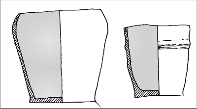
When these larger stones were removed it was discovered that, instead of the rab that occurred on the other three sides, the soil was “black, heavily burnt and full of charcoal”. Within this layer were found two small urns with considerably damaged rims, thought to be due to cattle using the stone as a rubbing post, placed one inside the other and standing upright on a small pile of charcoal. The urns only contained soil, with no trace of any cremated remains or bone, and were dated to about 600 BC.

A = compressed roots
B = soil
C = large stones
D = the two urns
E = burnt black layer with charcoal
F = charcoal
G = the rab
Cooke 2000 – a reconstruction based on the text.
The excavation report stated that, although no human remains were discovered, “there is clear evidence of a burial in the association of these two urns”, the smaller one carrying on an earlier tradition of a small pot accompanying a larger one as an “accessory food vessel”.
As neither urn showed any influence of local Later Bronze Age pottery traditions “they may both be regarded as isolated outliers of the Urnfield tradition further east along the coast (of Wessex)”. The urns were later presented to the Royal Cornwall Museum in Truro.*
Cooke 2000 after PWCFC (ns) Vol.1 Pt.2: 47
 This confirmed ancient menhir is particularly interesting in showing that relatively small isolated stones were used for ritual purposes, hence making it even more difficult to identify genuine ancient standing stones from modern cattle rubbing posts!
Privacy: we're not interested in your private data. This site collects stats to observe traffic in general only. we're not into capturing data, giving or selling your data to others or making mailing lists. Any problems, contact the webmaster. Enjoy your visit! | Website built with love by Palden Jenkins in West Penwith, Cornwall