Queried Menhirs in Morvah, Zennor and Towednack
Queried Menhirs
Queried Menhirs in Morvah, Zennor and Towednack
On this page...
Morvah
MORVAH 3
CROFTO
stone at 4060/3421, in a field, not marked on OS.
A survey during 1986* located a small stone standing in the centre of a field immediately east of Crofto Farm. It is only 1.5 metres (4’9”) high with a tapering top and no sign of any drill marks or other signs of having been split. Although entered in the Sites and Monuments Record as a possible menhir the stone was considered to be probably modern – a cattle rubbing post.
MORVAH 4
DAKOTA
stone at 4200/3499, in a croft hedge, not marked on OS.
A standing stone was recorded* as being incorporated in a hedge on the boundary of Morvah and Madron parishes during a survey in 1985. No further information was given. I went to the site in February 1997 and found the 2 metre (6’6”) tall stone in a hedge between bracken and gorse covered moorland and uncleared croft land littered with stones embedded in the turf. The stone is of immense girth at the lower end that is firmly embedded in the ground; it tapers towards the top but is not shaped. However, unless it was part of a prehistoric settlement (of which there are many in the vicinity) it is difficult to give another reason for its existence although it could have once acted as a marker on the prehistoric ridgeway track now known as the Tinners Way as it stands only a few yards from the original route. There is another tall stone a few metres along the hedge to the east and yet a third stone rises above the hedge someway beyond this but appears to have been dumped as part of land clearance.
MORVAH 5
KERROW
stone at c.4131/3460, in croft land, not marked on OS.
The 1985 survey* located and recorded a possible fallen menhir in a croft on the southeastern slope of Carn Downs. The stone appears as a triangle 1.2 metres (4’) high when viewed from the south and is 1.5 metres (5’) wide at its base. Some smaller stones were considered to have been possible packing stones although, situated as it is within a prehistoric field system, it could be part of a field bank. I was uncertain if I had found the correct stone when I went looking for it in February 1997; the only candidate seemed to be an insignificant stone in an area of rough ground grazed by cattle and littered with stones of many shapes and sizes.
MORVAH 6
HIGHER TREVOWHAN
destroyed stone at 4089/3512, formerly in a cultivated field, marked on the OS(1906) 6” map as Stone and still shown on OS(1995) as Standing Stone.
A possible menhir was first noted here by Henderson* as a five foot tall stone that was seen by Russell in May 1965. She remarked* that it stood in the corner of a field and was much weathered, and “apart from this, it could easily be a modern scratching post”. Measured as being 1.65 metres (5’6”) in height, the almost square-sectioned stone was deliberately uprooted during field clearance about 1982.* The site, close to prehistoric settlement remains, slopes towards the coastal plain with a wide expanse of ocean to the north and Morvah village below.
MORVAH 7
LOWER TREVOWHAN
missing stone at c.4034/3567, from Longstone Croft in TA(1840) No.274, not marked on OS.
In February 1966 Russell saw* a “flat granite slab, sub-triangular” about 1.7 metres high, 1.55 metres broad at the base, and tapering to 0.77 metres at the top (5’6” by 5’ by 2’6”). It seemed to her that it was larger than a normal scratching post; there were many other flat stones in the surface of the field at that time. The site is located north north east of Morvah Church in fields bordering the cliffs. Barnatt* put the grid reference at 4034/3561 somewhat south of Russell’s reference: no standing stone is now evident at this location which is close to the site of a destroyed cromlech – several hedges appear to have been removed in recent decades and perhaps the stone was uprooted and removed at that time.
MORVAH 8
ROSEMERGY
destroyed stone from 41/36, not marked on OS.
Col.Hirst recorded* the site of a destroyed menhir at Rosemergy during the 1930s but gave no precise grid reference. Nothing else is known of this stone.
Zennor
ZENNOR 2
HIGHER PORTHMEOR
stone at 4324/3726, in cultivated field Long Stone Field TA(1839) No.282, marked on OS as Standing Stone.
Quite a detective story surrounds this 2.1 metre (6’9”) stone standing in a cultivated field close to a former major churchway path crossing Zennor parish from Bosigran to the Parish Church. The Lanhydrock Atlas* from the late 17th century marks the field immediately to the north of the standing stone as Manskrethes (the inscribed or written stone) but the field called Long Stone in 1839 was not named since it belonged to a different landowner. By the time of the 1839 Tithe Apportionment Survey the Manskrethes field was called Higher Long Close (No.281) – see remarks below.
Blight visited the area with two companions during the 1850s after being told by an old man from Zennor that there was a stone known locally as Men Scryffas – perhaps he thought it might be an inscribed stone similar to that near the Mên-an-Tol. The ‘inscribed’ stone was found and Blight wrote* that there was a “stone about 100 yards from Polmeor Farm (Porthmeor) on which the south hedge of the road to Zennor has been built, it is about 6 feet long and one and a half wide. It has been called an inscribed stone but the outer face is only scored by rectangular cuttings or (word unclear) work”.
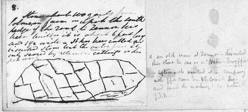 He made a rough ink sketch of the stone whose markings were considered to be natural. The stone is still there (1999) built into the roadside hedge but I could not see any evidence of markings and it seems very strange that Blight made no mention of the present standing stone which would have been in the field a few yards away behind him.
Blight Miscellaneous 46 (8). Reproduced courtesy of the Morrab Library Penzance
In 1879 Copeland Borlase excavated around the base of the standing stone in field TA282 but found nothing; his drawing shows the stone to be 6’8” tall (2.1m) of almost square section.*
The situation was further complicated when Hirst was informed* by Arthur Berryman of Porthmeor Farm that his father had told him that, about 150 years ago (i.e. c.1780), this stone lay on or below the ground surface and, being in the way of cultivation, was erected in its present position. The story was handed down in the family and Hirst considered it to be corroborated by the appearance of the stone which was least weathered on the side facing the prevailing wind, whereas in all other cases of ancient standing stones the weathering is more or less even all round. But that this did not necessarily mean that it was not a menhir – “It may be one which fell long ago, or which was intentionally knocked down – and re-erected as Mr Berryman believes”. Hirst noted that it was in current use as a cattle-rubbing post.
On 6th November 1924 Hirst examined the nearby ‘inscribed stone’. In his notes he wrote that:
“The stone now lies in what was originally the southern hedge of OS Field No.(number not inserted), where name is Mines Stristhes = inscribed stone. In that field today no stone can be found that is definitely inscribed and it is just possible that the peculiar natural weathering to be observed on this stone may have led ignorant people to assume that it was artificially inscribed. The stone is over six feet long and it is evident that it has been moved to its present position since it lies a-symmetrically to the face of the wall in which it occurs. It is not impossible that besides being one of one or more supposed inscribed stones, the stone was actually a menhir or long-stone. The weathering to be seen on this particular granite block is similar to that noticeable elsewhere on the local coarse granite, but I have not seen it anywhere in such a large piece of stone.”
A photograph by S.A.Opie shows the peculiar angular weathering quite distinctly.*
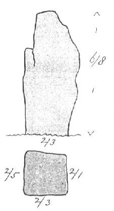 Russell later elaborated upon Hirst’s notes* and makes some intriguing comments told her by Dorothy Dudley, who had in turn been told the information by Hirst. Apparently, when the road was being widened more stone was needed and the workmen got the farmer to agree to take the menhir (i.e. the ‘inscribed’ stone) for that purpose. Locals were so incensed by this act that an attempt was made to re-instate it but, by this time, the stone was already embedded as a grounder in the hedge, so the farmer brought another stone to the field and re-erected it in the approximately the same position! Dudley pointed out the ‘inscribed stone’ mentioned earlier saying that this was the original menhir, which, because it had weathered into innumerable small cracks, looked like ogham writing and had hence given its name to the Field of the Written Stone. Russell wrote that “there is clearly confusion here” since the menhir field is called Long Stone and the next field, No.281, is Mines Stristhes* “so the stone now in the hedge (the one noted by Blight) may have been somewhere in TA No.281 and given its name to it”. She thought the present standing stone in TA No.282 had nothing new about its appearance and could probably be identified for certain by comparison with Copeland Borlase’s drawing.
Lukis (1885) Plate XXX
All these somewhat complex stories would make sense if the ‘inscribed stone’ now in the hedge originally stood as a menhir in field No.282, but was replaced by the present standing stone after the farmer agreed for the ‘inscribed stone’ to be uprooted and used as part of the new roadside hedge. This must have happened about the time Blight saw it (i.e. before the 1850s) since the (then) new Tithe Apportionment Survey had just recorded No.282 as Long Stone Field and would not probably have done this had there been no standing stone there – it was perhaps common local knowledge that this standing stone was a modern replacement. If this is correct then it is no wonder that Borlase found nothing and that Blight did not bother to mention it.
ZENNOR 3
BOSPORTHENNIS COMMON
stone at c.4428/3610, on moorland, not marked on OS.
I found this 0.9 metre (3’) tall roughly triangular-shaped four-sided quartz studded stone in April 1988. It is located in a wide expanse of moorland overlooking a valley with the rocks of Little Galva and Hannibal’s Carn on the skyline beyond.
There are many small erect stones on this area of open moorland. Some are rough granite stones inscribed with Z, M or G, indicating their use as parish boundary markers for Zennor, Madron and Gulval. Other stones are cut rectangular blocks, with incised letters indicating ownership of the land, used as 18th and 19th century estate boundary marks.
ZENNOR 4
BOSWEDNACK
displaced stone at 4441/3787, gatepost to TA764 Long Stone, not marked on OS.
Boswednack
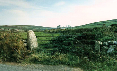
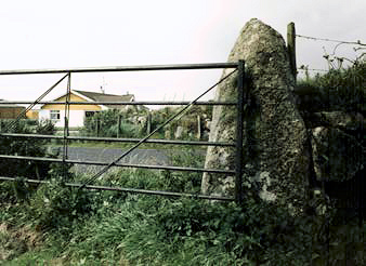
 A 1.75 metre (5’9”) tall slab of granite, widening towards the base, is now in use as a gatepost to a field next to the coast road just south of a field named as Long Stone in TA(1840) No.764. The stone was recorded at its present location during the mid-19th century* and Hirst had his photograph taken leaning against it; he thought that, being well weathered and of considerable bulk, there could be little doubt that it was a menhir, although not in its original position.*
 ZENNOR 5
KERROW
stone at 4478/3807, in cultivated field, not marked on OS.
Kerrow
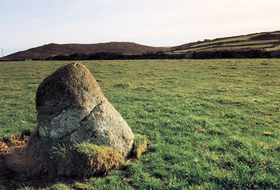 A 1.3 metre (4’3”) standing stone was recorded* in the south-western corner of a field during a 1985 survey but was considered to be a rubbing post rather than a menhir. Hirst mentioned* a longstone at Kerrow but gave no grid reference and wrote how it had been broken up by Mr William Nicholls, owner of the farm, “who admits that his father before him did a great deal of ‘tearing down’ of things which were erected by the old people”; Hirst also noted that other possible menhirs in the parish, suggested by their size, had been broken up and removed.
I went to this stone in February 1997 and found it well away from any field hedge, with views of the Galvas on one side and Zennor Carn on the other; it looks like a rubbing post and another small stone can be seen over the hedge in a field south of Kerrow at about 4499/3779.
ZENNOR 6
TREGERTHEN
missing stone from c.4687/3883, in moorland, not marked on OS.
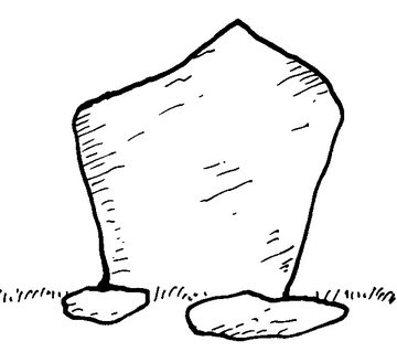
In January 1961 Russell noted* a possible menhir standing in uncleared steeply sloping land north of the Eagles Nest. The stone was both 3.1 metres (10’) high and wide, and 0.46 metres (1’6”) thick; she noted that it seemed “unlikely that it would have settled in this position without human aid” and made a drawing while admitting that her grid reference (see above) might be wrong. Neither an OS visit in 1975 nor a National Trust survey in 1984 could find any trace of such a stone at the location given.*
Cooke 2000 after Russell Collection
ZENNOR 7
TREMEADER COMMON
missing prostrate stone from c.47/37, on moorland, possibly marked on OS as rock.
About 1740 Dr.Borlase, in his description of Zennor Cromlech and its surroundings, wrote* that:
“There is another Quoit also near the adjoining carn about 200 yards to the north-east (Sperris Quoit?) and not far - not half a mile - from the first Quoit to the south-east is a very long stone lying along near the high road which was returned up and examined whether inscribed or not, or whether only the kind of those at Boleit in Buryan.”
The high road was the old packhorse trail to St.Ives, now known as The Tinners Way, which was then the only route between St.Just and St.Ives to avoid travelling through all the intervening farms along the coastal plain. The whereabouts of this stone has not been established* and, when I went to the area in March 1997, dense gorse and other vegetation made it virtually impossible to locate anything along the edges of the track. However there is a large stone about 3 metres (10’) in length and 0.45 metres (18”) thick lying on the ground (rather than embedded in the turf) at 4686/3666 by the side of the track some distance away from Borlase’s supposed location. This stone is marked on the OS(1906) 6” map as rock and has drill marks down one of the long sides and a single drill hole on the upper face. It is perhaps possible that it was once a menhir that was split (to make gateposts?) and dragged along the track from where Borlase had seen it.
ZENNOR 8
TREWEY
stone at 4528/3845, in a hedge, not marked on OS.
A “prominent stone” was recorded* during 1988 in a hedge close to the stream northwest of the Wayside Museum.
ZENNOR 9
TREVEGLOS
possible stone row at c.453/389, not marked on OS.
A possible stone row was discovered in the late 1980s during archaeological field work in the area.* At one end is a stone (A) in a hedge at 4528/3891 with two other stones in the field; one standing (B), one fallen (C). The alignment then continues to another stone (D), 2.6 metres (8’6”) tall, being used as a gatepost. The stones align east-northeast to west-southwest and point towards Zennor Carn. Payne noted the north westerly stone as being 2.37 metres (7’9”) tall but considered it “very doubtful” if it was part of a prehistoric stone row.*
ZENNOR 10
TREEN
missing stone from c.4447/3665, part of a prehistoric enclosure, marked on OS as Enclosure.
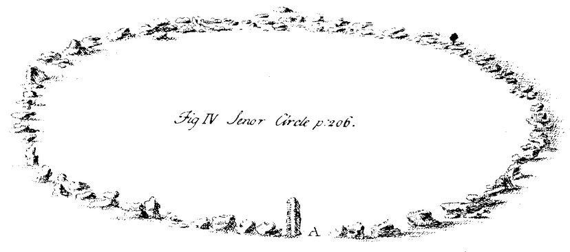
W.Borlase (1769) Plate xv (opp. page 198) A = the large stone mentioned in his text.
Dr.Borlase wrote* that: “In the higher end of Treene...is a circle of stones 27 yards diameter. These stones are small, neither very large, nor erect, but scattered in a circular order, only that at the southernmost point there is a long stone erected ‘tis call’d Luach an Dygee”.*
 By comparison with the Irish language he suggested that this site could be a sanctuary to the moon and that “perhaps whatever offender touched the upright stone was afterwards free from punishment”.
This site is the Senor Cirque figured in his published work* that shows an engraving with the tall stone seemingly by an entrance gap into the enclosure of loose stones. It is likely that it was once part of a pair of stones forming a gateway: Borlase later considered the site to be “an elective circle”. As with the sites at Tredavoe and Kerris this stone might just have been a menhir incorporated into a later structure. At the present time (March 1997) there is an upright stone about 1.2 metres (4’) high on the south side of the monument, with a few others lying on the ground amid low gorse.
Towednack
TOWEDNACK 2
BEAGLETODN DOWNS
stone at 4770/3829, not marked on OS.
An “orthostat” standing 1.2 metres (4’) high was recorded in 1986* and suggested as being of “prehistoric date”.
TOWEDNACK 3
TRINK
stone at 5022/3714, on moorland, marked on OS(1906) 6” map as Stone.
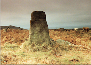
This 2 metre (6’6”) stone was visited by Guthrie during the late 1970s and described* as a substantial quite weathered moorland block, tapering on one face and sub-rectangular on the other, and appeared not to have any relationship with the nearby workings of Giew Mine. However, a more careful later study* of the stone revealed a hole drilled into one side and it was remarked that “even if it were not originally part of a mine building it looks suspiciously as if it has been adapted for use”. The stone stands amid thick gorse but can be reached with difficulty along a narrow path; the sea is visible on both the southern and northern coasts.
Privacy: we're not interested in your private data. This site collects stats to observe traffic in general only. we're not into capturing data, giving or selling your data to others or making mailing lists. Any problems, contact the webmaster. Enjoy your visit! | Website built with love by Palden Jenkins in West Penwith, Cornwall