Menhirs in Madron
Definite Menhirs
Menhirs in Madron
MADRON 1
KERROW menhir
at 4145/3425, in a hedge at former junction of three fields, not marked on OS.
Kerrow with Morvah Carn beyond
 A 2.1 metre (7ft) stone stands in a field hedge just north of the narrow road to Greater Bosullow. It tapers towards the top and a crack on the eastern face is described in the SMR* as “a short weathered groove of little significance” but, with the base partly concealed by a packing of earth and stones, “it is reasonable to suppose that the wall has been constructed to abut the stone which is in situ”.
C.Henderson Antiquities Vol.2: 22. Courtesy of the Royal Institution of Cornwall

In March 1952 Russell noted* the menhir as being at the junction of three field hedges, one of which has since been cleared away.
Henderson earlier wrote that the stone was in the hedge of a field about 100 yards (80m) east of Kerrow Farm and described a six foot high (1.8m) “fine stone which was in all probability a menhir”.*
In 1856 Blight listed* a Monumental Pillar six feet (1.8m) high at Kerrow Hill, Morvah, but whether this is the same site is unclear – Kerrow is near the borders of Madron and Morvah parishes.
MADRON 2
TREMAYNE menhir
at 4297/3136
W.Borlase (1769) Plate x (opp. page 154)
 Only a single stone 1.9 metres (6ft 3in) tall now remains of a former pair at this location. They were placed about 3 metres (10ft) apart in a north-east to south-west alignment in a field behind the present farm which was built since 1800 in a tenement previously part of Trewern.*
Dr.Borlase* described the stones in 1740:
“In a croft adjoining the highway leading to the parish of St.Just, and near a Cott house call’d Beggar-boyes, stand two large stones in a line...there is a row of stones running from them in a straight line...”
C.Henderson Antiquities Vol.2: 3. Courtesy of the Royal Institution of Cornwall
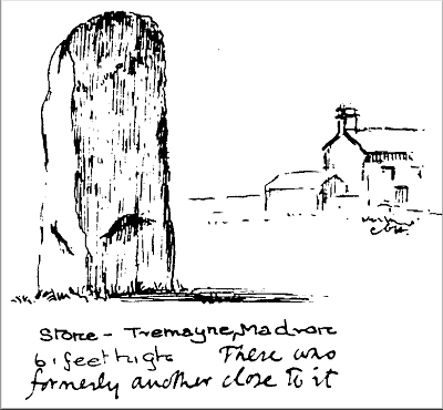 He thought that these were all boundary stones or the “monument of some duel” and he later excavated between the two menhirs. A pit 1.86 metres long by 0.85 metres wide by 1.40 metres deep (6ft x 2ft 9in x 4ft 6in) was uncovered and found to be filled with “black greasy earth”: Borlase remarked that no bones were to be seen.
Just over a century later Copeland Borlase* was present when the ‘grave’ was re-opened by the landowner: his ancestor’s account was fully confirmed although the black soil was considered to be “peat natural to the country”.
Both stones were then in place, but, by the time that Charles Henderson* visited the site about 1915, only a single stone was left in place: when questioned the farmer replied that “one rubbing post was quite enough”.
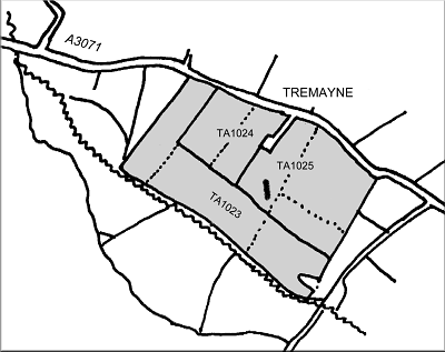
TA 1023 Long Stone Common (rough pasture),
Long Stone Downs (1024 arable & 1025 furze)
Some errors have been made in recent times by confusing Dr.Borlase’s record of the pair of stones at Trewern (Tremayne) with the pair of stones formerly near Trewern Round.
For the destroyed stone see MADRON 7.
MADRON 4
BOSULLOW missing menhir
from c.4185/3458, in former area of croft, not marked on OS.
C.Henderson Antiquities Vol.2: 22. Courtesy of the Royal Institution of Cornwall
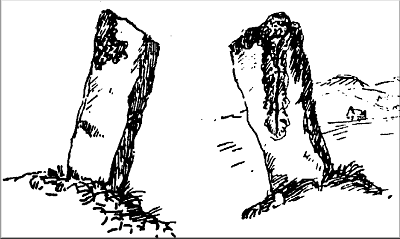 A 2.1 metre (7ft) tall stone was recorded by Charles Henderson about 1916*: “On the same downs (as Men Scryfa) not far from the road from Lanyon to Madron where it is joined by the lane from Men Scryffa – near Bosullow Schoolhouse – is a menhir. It stands on what was apparently once a mound of earth and small stones and leans considerably to the south. It reaches a height of 6 feet 10 inches and is about 2 feet broad. It tapers at the top and has a crack down one side. There does not seem to be any reference to this stone among the many books which have been written on the subject”.
On a map of the parish he marked the stone in rough ground about halfway between Dakota Farm and Bosullow Schoolhouse (now the Men-an-Tol Studio). Considering the large number of visitors using this lane to visit the holed stone and Men Scryfa it is odd that it was not mentioned previously, unless, perhaps, it was then obscured by tall scrub and gorse which had been burnt off by Henderson’s time – the OS 6in map of 1906 still marks this area of land between Dakota Farm and the Men-an-Tol Studio as partially enclosed croft land (i.e. uncleared for ploughing). It is unknown when the stone was uprooted but Mr Lennox Green, a life-long resident at Bosullow since the 1920s or 30s, had no knowledge of any such menhir.*
Russell failed to locate the stone after a long search in December 1963: however she thought that the eastern gatepost of the first field on the left of the lane at 4190/3442 might be this elusive menhir although it seemed to her to be “unnecessarily tall”.* But a walk around the Bosullow area shows that there are many rough stone gateposts as tall as, or taller, than this one. She considered the menhir listed by Blight* at Kerrow might have been this stone rather than MADRON 1, since nearby fields (TA204, 206 and 207) were called Renow Hill - a possible misspelling of Kerrow Hill.
MADRON 5
LANYON missing menhir
from c.4292/3368, not marked on OS.
A huge longstone about 12 feet long dumped on a hedge to the east of the stone below. (5/2004)
 Dr.Borlase recorded* a high stone about 80 yards (72m) west-north-west of Lanyon Quoit close to the present minor road: the same stone was again mentioned by King in 1799.*
However, later visitors to the Quoit made no reference to any menhir which was probably destroyed before Rev.Cotton made his series of on-the-spot drawings in 1826 – no mention being made of any standing stone in his text.*
In his publication of 1817 Gilbert* had earlier mentioned the existence of this menhir although, since he quotes almost exactly from Borlase’s work, it must be doubtful whether he ever saw it. Blight noted* that the high stone had long since vanished and the nature of the stone’s disappearance must remain a mystery.
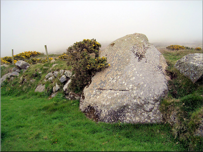 The north-east edge of fields immediately north-east of the quoit is littered with large stones that were probably dumped when the land was cleared: possibly one of these stones is the missing menhir.
Note: A 1.2 metre (3’9”) high stone at 4238/3427 placed mid-field and clearly visible from the road west of Lanyon Farm is a modern cattle rubbing post, as are several other stones in fields in the vicinity.
MADRON 6
LOWER NINNES missing menhir
from c.4508/3423. Not marked on OS.
Rough sketch from Lanhydrock Map 1696
 A menhir of unspecified height is marked on the Lanhydrock Atlas of 1696* in a field named Menheere in the Manor of Trezela and Mulfra.*
This field lies about one kilometre south of Mulfra Quoit from where the menhir at Carfury (GULVAL 1) is in sight below the horizon line. Nothing more is known of this stone.
Privacy: we're not interested in your private data. This site collects stats to observe traffic in general only. we're not into capturing data, giving or selling your data to others or making mailing lists. Any problems, contact the webmaster. Enjoy your visit! | Website built with love by Palden Jenkins in West Penwith, Cornwall