Queried Menhirs in Sancreed and St Just
Queried Menhirs
Queried Menhirs in Sancreed and St Just
Sancreed
SANCREED 5
BOSLOW
missing stone, location unknown.
Blight recorded* a Monumental Pillar 2.79 metres (9’) tall on Longstone Down, Boslow, St.Just in 1856. Boslow, actually in Sancreed Parish, is not far from Boswens Menhir that he listed separately. Whether this was a typographical error, or whether there was actually another standing stone in this area is unclear. No reference was made by any other writer to such a stone.
 SANCREED 6
NEWHAM
missing stone from c.415/290, in a field, not marked on OS.
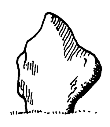
Charles Henderson recorded* a 1.55 metre (5’) stone immediately to the east of cottages at Rose Valley, Boswarthen, and wrote that it stood in a field “through which passes the footpath from Sancreed via Newham to Boswarthen cottages” (i.e. the old churchway path). He made a drawing of the stone and marked it on his map of the parish, supposing it could be a small menhir or rubbing post. No remains are now recorded* and Russell thought that Henderson’s drawing did not look much like a menhir.*
Cooke 2000 after C.Henderson Antiquities Vol.1: 23
SANCREED 7
NEWHAM
displaced stones at c.4172/2916, in garden hedge, not marked on OS.
A possible menhir-shaped stone, 1.93 metres (6’4”) tall and about 1 metre (3’3”) wide at its widest point near the base, was discovered in 1996 by a farmer while clearing a garden hedge close to the old Brane to Sancreed churchway path.
One side appears to be shaped and the stone, not being earthfast, must have been uprooted at some time, possibly when the field level was considerably lowered during the 1920s at a time when the present house was constructed.* Payne thought it likely that there was a connection between the stone recorded by Henderson (SANCREED 6) and this stone* but Henderson’s sketch makes this improbable.
Yet another stone, with a triangular-shaped top, was found close by in the hedge behind the above stone and was thought to represent the second stone of a former pair at this location. Several contemporary menhirs are in view including The Blind Fiddler, Tresvennack Pillar and Chyenhal.*
SANCREED 8
WHEAL BULLER
re-erected stone at 4025/3186, in roadside hedge, not marked on OS.
A huge 4.65 metre (15’) long stone was discovered when the driveway to Wheal Buller Farm was being widened beside the B3318. It was decided to erect it during the summer of 1989 so that it could easily be seen and it now stands 3 metres (10’) tall above the ground.* It just might be the stone mentioned by Blight (SANCREED 5) and is located about half a mile from Boswens Menhir.
SANCREED 9
TRENUGGO
stone at 4275/2795, in cultivated field, not marked on OS.
A 1.5 metre (5’) stone stands in a field on the opposite side of the road to The Blind Fiddler to make a perfect visual alignment with the top of Sancreed Beacon.* However the farmer maintains that the stone was not ancient* and it is in current use as a cattle rubbing post located well away from any hedge.
SANCREED 10
BOJUTHNOE
missing stone from c.415/324, not marked on OS.
Copeland Borlase made a plan in 1871* of remains of ancient huts at Bojuthnoe, some 200 metres east of settlement remains at Bodinar: on it he marked a Longstone about 3.3 metres (11’) long lying on its edge a few metres outside the wall of a dwelling. He thought that it had once stood upright. No other reference is known.
St Just
ST.JUST 2
BOSAVERN
stone at 3727/3033, in a field, not marked on OS.
A menhir or rubbing post stands near the edge of a field and has a possible alignment from the nearby Tom Thumb Rock at 3682/3061 to ST.BURYAN 4.*
ST.JUST 3
CHAPEL CARN BREA
stone at 3867/2847, in a low hedge, not marked on OS.
Michell recorded* a possible menhir 2.15 metres (7’) tall as being in its original position but now part of a fence around a pigsty or chicken run.
ST.JUST 4
CARN EANES
erected stone at 3840/3374, on open ground, not marked on OS.
A 2.2 metre (7’) tall stone was erected about 1986 on rough ground near the summit of the carn. Its discovery is intriguing.
The surrounding area was ravaged for years by quarrying and, during a healing ritual carried out by the Fountain Group based at Lelant, dowsing revealed the existence below ground level of a large stone thought to be a prehistoric menhir. Contractors, employed by the nearby Geevor Mine (then still in operation) to clean up the many mine waste dumps in the locality, were contacted and asked to unearth the stone and erect it. This was done and the stone was found to be “newly quarried and unweathered”.* There are a number of other recently erected stones in the vicinity.
Privacy: we're not interested in your private data. This site collects stats to observe traffic in general only. we're not into capturing data, giving or selling your data to others or making mailing lists. Any problems, contact the webmaster. Enjoy your visit! | Website built with love by Palden Jenkins in West Penwith, Cornwall