How Alignments are Researched
Making the Maps
This page outlines issues that needed consideration in the making of the maps.
Lower down:
Acceptable Types of Sites
The kinds of ancient sites that are accepted as valid alignment points are:
- Significant hilltops, headlands, tors, carns (outcrops) and large natural rocks;
- Hill camps and enclosures (hillforts), cliff castles (headlands) and rounds (lowland enclosures);
- Stone circles, quoits and menhirs;
- Holed stones, propped stones, old boundary stones and other deliberately placed stones;
- Cairns, barrows and tumuli - whether chambered or solid;
- Ancient settlements, hut circles (round huts) and villages - though these are less reliable as decisive points in an alignment by dint of their size and indefinite edges, and they generally do not show signs of being deliberately aligned to ancient sites;
- Fogous (underground chambers) and holy wells - though these two kinds of subterranean site don't seem to figure much in alignments;
- Old churches (early medieval in foundation) and early Christian oratories and crosses (many of which are located on older ancient sites).
All known locations in Penwith, around 750 of them (list here), have been very accurately placed on the map – you can zoom in close on the Google version of the map to examine their precise locations. Some sites shown on the map are no longer in existence - they have been included as a result of researching records, excavations and other means.

Identifying Alignments
Aligned stone at Greeb, Land's End, with Longships Rocks behind
 Many alignments were already found over the previous 50 years by a variety of researchers, most notably John Michell and various contributors to Meyn Mamvro.
All alignments were triple-checked by the mapmaker, Palden Jenkins, the alignments list-keeper Raymond Cox and Cheryl Straffon, editor of Meyn Mamvro.
In identifying alignments, inaccuracies of up to only three metres (10ft) were accepted. There was occasional acceptance of five metre (15ft) inaccuracies in cases where major sites (such as stone circles or Neolithic tors) were involved. That’s a tight accuracy standard. To have four or five sites aligned like this over many kilometres is no accident, no matter what sceptics say.
To qualify as an alignment there must be a minimum of four points accurately located on it. Some geomancers accept no less than five points - this rule exists mainly to answer sceptics' doubts by reducing the statistical probability of alignments being randomly coincidental.
Ancient megalith builders were not worried about pleasing modern rationalists. Here in Penwith, omitting four-point alignments would miss much potentially valuable data. So four-point and even some three-point alignments are accepted as long as they are plausible in terms of the ancient sites they link together.
Three-point Alignments
In some specific cases three points have been accepted. This has been done in the following instances only:
- when an alignment is clearly obvious by dint of the specific sites that are on it - they must be relatively close to each other or have some connection, such as intervisibility, similarity of type or antiquity;
- short alignments radiating from stone circles, 1-3km in length, often astronomically or mathematically oriented, and part of the complexes surrounding stone circles;
- alignments connecting quoits. These are nearly all three-point alignments and, since there’s a distinct pattern here, these alignments are accepted (more here);
- alignments on Scilly, where distances are short and locational permutations are fewer than on the mainland. Three-point alignments are clearly at work here (see Scilly map);
- the Kemyel/Swingate group of menhirs just east of Lamorna, a localised sub-system of menhirs, erected seemingly for a special purpose that we’re yet to discover. Many are mutually aligned as three-point alignments.
If you examine these various instances on the map, you’ll see why these decisions were made. Apart from these, all alignments have four or more points on them - many of them more.
Lines of Sight
Mên an Tol
 These are not alignments in the classic sense, but when you're out in the landscape they are relevant. This concerns the intervisibility of ancient sites: many sites are deliberately placed so that they can be seen from other sites, and some are placed because, at that precise spot, other sites can be seen from them - sometimes this is quite ingenious.
Stand on top of Trencrom Hill, and Godrevy Head and St Agnes Beacon up the north coast of Cornwall, Carn Brea, Godolphin Hill and Tregonning Hill in East Penwith and St Michael’s Mount southwards in Mount's Bay simply yell at you - they're very visible from Trencrom, drawing attention toward themselves.
These are an important element of the landscape psychogeography of Trencrom Hill and, in some cases, they form astronomical alignments. From Trencrom, the summer solstice sun rises NE over St Agnes Beacon, and the winter solstice sun rises SE between Godolphin and Tregonning Hills. Meanwhile, the summer solstice sunset sets NW in a nick between Trink Hill and Rosewall Hill. As seen from the central tor rock on Trencrom Hill, the sun is seen to roll exactly down the left-hand slope of Trink Hill until it sets behind Rosewall Hill.
Trink Hill, left, and Rosewall Hill, from Trencrom on summer solstice
 Similarly, if you stand at Chûn Quoit at summer solstice sunset, the sun sets in a nick in the rocks of Carn Kenidjack a mile away. This is not uncommon, and it can involve wholly natural sites. That's the wonder of it.
Prominent hills are important as a focus of attention. They give a sense of 'placeness' and orientation. Carn Kenidjack and Carn Galva in the north, and Chapel Carn Brea and Bartinney in the west, are dominant in the landscape, not just visually but also in terms of psycho-geographic presence. You definitely notice them.
Carn Kenidjack from Carn Lês Boel (telephoto shot)
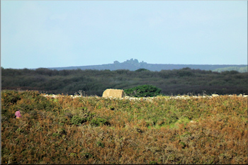 Carn Kenidjack is not very high but it stands out, sometimes from the most unexpected of places, including the Isles of Scilly. At Carn Lês Boel, six miles (10km) south, if you stand on a cairn near the carn (SW 3578 2331), you'll see Carn Kenidjack - but move just a few paces away and it disappears from view. This is just classic.
These two-point lines-of-sight lines are not counted as alignments - they are simply intervisible sites, hills and landscape features. They are mentioned here because, in the field, they are an important part of the spatial geomancy of West Penwith. Whenever you go to an ancient site, swing round and check out the visible landscape as seen from there.
Compiling the Map
Originally, ley-hunters worked with Ordnance Survey maps laid out across the floor, using long rulers and pencils. Nowadays we use Google Maps, which are based on aerial photography. The location of a site such as a menhir or stone can be identified accurately, and the full extent and shape of a barrow, enclosure or stone circle can often be seen on satellite photos - this is important since some alignments tangent their edges.
The map research was done both logically and intuitively. Operating logically, one can identify a site and swing a line round from it to look for alignments to that site - this can be done systematically. Operating intuitively is more spontaneous, done when the thought arises or while working on the map - at times I've found 3-4 alignments in 20 minutes, and other times it takes ages before a good alignment is found.
An example: musing that St Michael's Mount and Cape Cornwall have similar shapes and settings, the author played with a long ruler over his computer screen and, lo behold, an alignment appeared involving four sites - one of which, Botrea Barrows, was on the hill above his home. This set a process going. It led quickly to the discovery of several alignments, particularly of what became recognised as backbone alignments - not known of until that moment. This is how some of the best discoveries in this project have been made, intuitively, often over a cup of tea or late at night.
While the alignments map was being established, the first alignments to be added were those found by John Michell around 1970 - about 80 of them. Then others found by other researchers, logged in Meyn Mamvro over time, were added. Then further work was done to research new alignments.
As this process proceeded, it became clear that a jumble of alignments was forming, and that they seemed to be of differing levels of importance. Importance depended on the sites involved, the number of sites on an alignment and considerations such as the alignment's plausibility, in terms of topography or site antiquity. Thus began a process of grouping alignments into types.
All alignments have been numbered and listed in the alignments list, with the sites of all points on them. These and other details can also be found on the Google version of the map, by clicking on the line or on any point - details then pop up.
End of the map section

Privacy. This site uses temporary cookies to watch general trends only. We aren't selling anything, capturing, mining, passing on your data or making mailing lists. It's a public service - no strings. Any issues, please make contact.